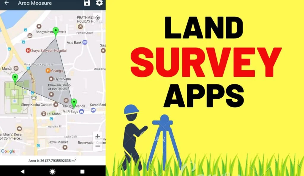
It is challenging to measure land without any tool that helps you to give accurate measurements and readings. These applications include tons of measurement tools and calculations done in a split second. They are readily available for you to measure land of any shape or size.
These tools were unavailable in previous years, and people had to measure giant properties with different formulas and tactics. As the computer era has turned a new leaf and technology has improved, you can access separate applications to measure land without expert help.
What are Land Surveyor Apps?
There are different methods of measuring areas like survey map tools, entering coordinates on the map, and many other ways. These applications include settings, health centers, measurements saving, environment feedback from the developers, and many more functional features.
These applications are quite handy for engineers and site managers to measure the distances and add marks. You can integrate the app with Google Map to servey particular locations on the map from your home or office. The element of inaccuracy has been reduced to provide correct results.
Best Land Surveyor Apps for Android and iOS
Developers build an app that will enable us to measure areas with the help of GPS tracking, different types of field measurements by distance marking, and various other ways. Here is a list of different land surveying apps; some devices are easy to use and have a good user interface.
1. Simple GPS Survey
Simple GPS Survey is a simple interface application that allows the user to measure the land perimeter without any help from a device. It is a useful application for recording the coordinates of a location the GPS functionality is available and provide local latitude and longitude point of view.
A GPS server can provide the functionality of recording a large number of location details and can be saved under any name. It can also delete point measurements and restore them or manipulate the data. The interface of the application consists of multiple settings and a simple structure.
Features
- Capture Longitude
- Store Latitude
- Save Multiple Location
Pros
- And Pint labels
- Editing Option
Cons
- No live Support
- Outdated Platform
2. Geo Measure Area Calculator
Geo Measure Area Calculator is a beautiful application that allows the user to measure the land in any way and provides many tools for accurate measurement. The app can calculate the GPS area in GPS distance with high accuracy improved coordinates to mark your property.
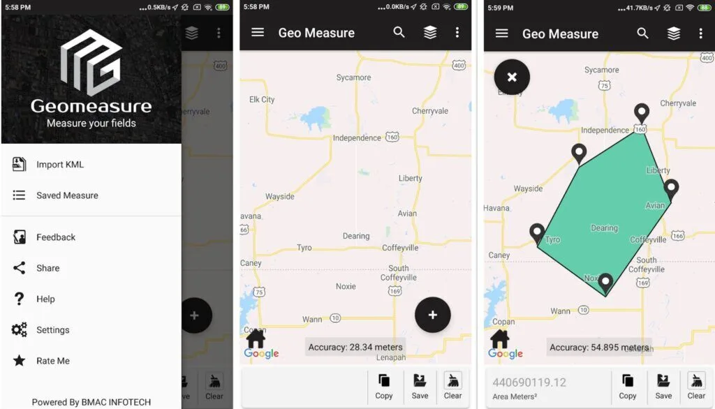
It comes with tons of features like manual measurement, which allows you to put a marker on the map, GPS measurement, which will enable you to walk to the distance from point to point, and many other ways to measure the land. The GUI structure has a beautiful layout and a fantastic theme.
The application’s core feature consists of deleting marker place, sharing with your friends and family, saving the measurements for later use, calculating the distance and area, having multiple map views, dragging and dropping the marker to place the marker, and various other features.
Features
- Add Marks on Maps
- Delete Marker Places
- Distance Calculation
Pros
- Updated Interface
- Results Sharing
- Save Calculated Area
Cons
- No Developer Access
- Lacks Advanced Maps
Download: Geo Measure Area Calculator for Android | iOS
3. Map Pad GPS Land Surveys & Measurements
Map Pad GPS Land Surveys & Measurements is a smart interface application that allows the user to calculate area perimeter distance and save export the measurement to other devices or your friends and coworkers. The app can measure land in different ways on the map.
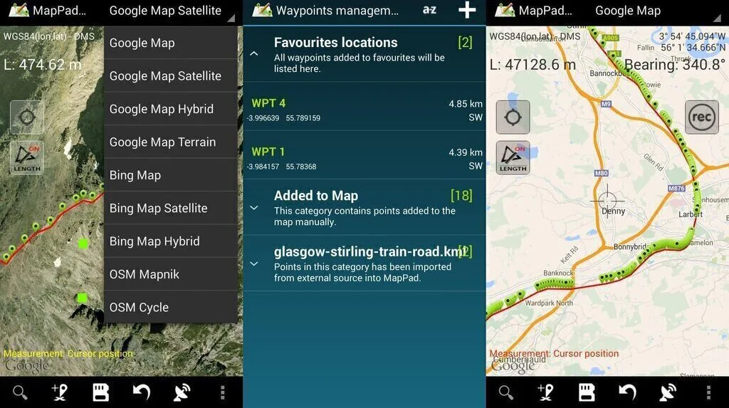
The primary function of this application is to capture the length measurement using real-time GPS tracking and allow you to upload your analysis directly to the cloud storage. It comes in handy for anyone involved in agriculture, forestry roofing, and many other land measurements.
It is full of features such as capturing way-point and grouping them into categories, exporting single or multiple measurements, elevation profile available for analysis done by GPS, setting default measurement, and many other tools and measuring options.
The app interface provides a straightforward GUI structure, which is easy to use and has a user-friendly theme. Map Pad GPS Land Surveys & Measurements contain ads, and those ads are removed by in-app purchases, which also unlocks additional features.
Features
- Base Maps
- Three Method of Measurement
- Google Maps Overlays
Pros
- Imperial Units
- Capture Waypoints
- Add or Edit Titles
Cons
- Incorrect Final Measurement
- Not of iOS Systems
Download: Map Pad GPS Land Surveys & Measurements for Android
4. Land Surveyor
Land Surveyor is a land surveying application for Android devices that allows the user to calculate the land area, distance from two points, and coordinated structure of the property. The app comes in handy for civil engineers and users who have the slightest knowledge of measuring the area.
It uses various formulas in analysis using the geometric method for the oddly shaped plot, which is much easier to get the numbers. Then the user is allowed to save, load, edit and delete all measurements within the app so that the app runs the calculations and saves the result.
The user can also convert different data readings like turning square meters into cents, acres, and hectares. The application is free to use, contains ads, and has no additional purchases. Its interface has a smart and interactive GUI structure that helps the user navigate.
Features
- Calculate Area
- Plot over Graphs
Pros
- Attractive interface
- Square Meters
Cons
- Inaccurate Data Collection
- No developer Access
5. Total Station Survey
Total Station Survey is a paid application that requires the user to input the measurement or constructs of the land measurement or a point-to-point distance. It consists of many types of surveys and setting features that allow the user to survey an area of any type and anywhere in the world.
The device and the application are set to measure the precise and the most accurate survey reading. It contains many features tons of tools that civil engineers use, it also syncs with the total station Topo survey, and it can be connected over Bluetooth or via USB connection.
Some important feature of the app contains a particular export format, survey data in 2D view, backup and restore data, calculate area, create pinpoints, and many other features. Total Station Survey has an excellent interface, which is to the point and provides tons of tools listed in categories.
Features
- Email Notification
- N-Point Calculation
Pros
- Unit Setting
- Save Project Data
Cons
- No Live Customer Support
- Outdated Services
6. GPS Fields Area Measure
GPS Fields Area Measure is a cross-platform application, a simple, accurate, and convenient tool that measures distance perimeter area from one point to another or a full land. This app accurately measures high-speed marking of distance train increase accuracy points.
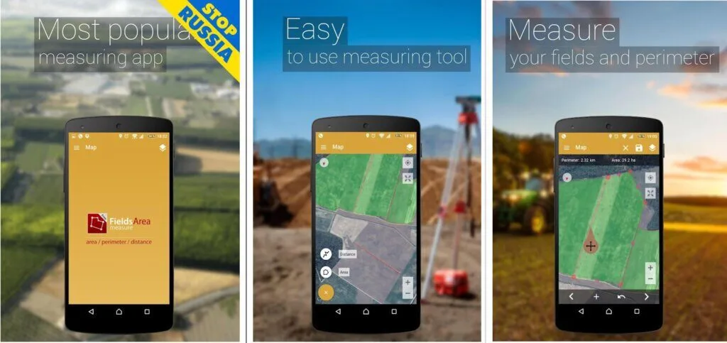
It consists of various functions that measure the land according to requirements. The app edit, change names, assign groups, or exchange measurements. It executes all analysis and calculations and automatically generates links with the limit of the selected area route or marked direction.
The dashboard provides easy approach measurement and a simple, attractive look for uses. GPS Fields Area Measure is free to use and offers ads and in-app purchases to unlock more features. The application interface is easy to use and provides the tools required for calculation.
Features
- Fast Area loading
- Distance Marking
Pros
- Smart Marker Mode
- Edit Measurement
Cons
- Expensive Paid Version
- No Live Support System
Download: GPS Fields Area Measure for Android | iOS
7. Land Calculator: Survey Area, Perimeter, Distance
Land Calculator: Survey Area, Perimeter, Distance is an application that consists of tools that allow users to measure the land using GPS coordinates. Users can use different measurements like longitude and latitude coordinates, point-to-point direction, unit constructs, and more.
The application contains features like using KML tools, measuring the shortest distance to a line without connecting geodesics, measuring the point-to-point distance with devices, creating a field survey by drawing any shape on the map to an enclosed area, and other measurement tactics.
Features
- GPS Controlled Compass
- Restore Data
Pros
- Structured Interface
- Data Generation Methods
Cons
- No Kms File Import
- Limited Waypoints Entry
8. GPS area measure – land survey
GPS area measure – the land survey is a beautiful application for GPS area measure and land survey. App measure acreage, acres to square feet, assist in land survey, measure the total distance of your way-point, calculate perimeter, area measurement, GPS work, and field area measurement.
GPS area measure – the land survey will measure every step of the way to provide you with an accurate result. The interface of this application is simple and easy to navigate and provides all the information. It has a beautiful display that is easy to read and understand.
The working of the app is a bit different from others in this category because a simple interface requires you to click the button “GPS WALK,” and you start walking along the border of the area if you stumble upon an obstruction, press pause, then press “continue” and keep walking.
Features
- Calculate Acreage
- Unit Conversion
Pros
- Assist in Land Survey
- Calculate Parameter
Cons
- Unstructured Interface
- Lacks Advanced Navigation
Download: GPS area measure – the land survey for Android
9. Surveying in the Field
Surveying in the Field is a to-the-point application that provides the user with efficient tools to measure the land for accurate results. The app offers land measurements from one point to another on the perimeter area in any analysis that the user demand.
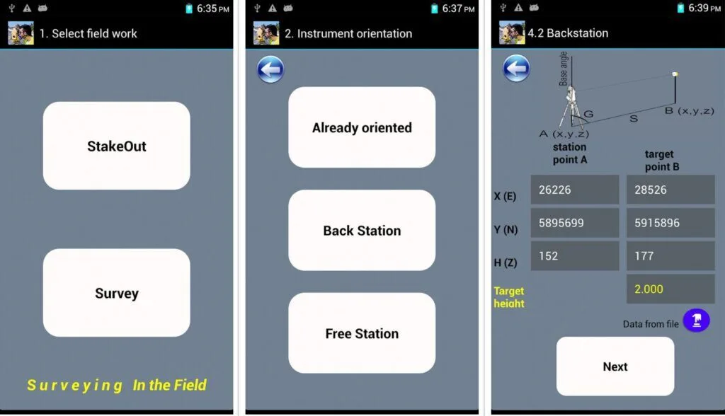
Its consists of all the numerical digits and calculations you need to perform during the survey. It extended the feature where you can use data from the file or input your data. The free version contains ads, and the pro version unlocks features, measurement tools and removes the ads.
In survey mode, you can store the measurement and content for later use and edit or delete the analysis according to the user’s consent. Surveying in the Field is free and does not contain ads or purchases. This application comes with a free and paid version with an easy-to-use interface.
Features
- Multiple Total Stations
- StakeOut Mode
Pros
- Store Measurement
- Free to Use
Cons
- No Back Stations
- Difficult to Understand
Download: Surveying in the Field for Android
10. Surveyor
Surveyor is an app consisting of surveying tools and allows the user to measure the land distance with the help of GPS coordinates tracking. The critical function of this application is to provide an accurate measurement of a virtual ground that is overlaid on the camera image.
The app has a simple-to-use interface and provides ease of navigation. The readings of Surveyor are altered, and they can be edited and manipulated in any way users require. The distance between each marker calculates and displays MS units on the screen specifying the tags’ pain points.
Features
- Measure Measurements
- Virtual Grounds
- Overlaid Camera Images
Pros
- Surveyor Locks
- Clean Interface
Cons
- Not for Professionals
- Limited Units
Download: Surveyor for Android
Conclusion
Land Surveyor apps are quite handy for engineers and site managers to measure distances and add marks. You can integrate the app with Google Map to servey particular locations on the map from your home or office. The element of inaccuracy has been reduced to provide correct results.
In this article, you have read about the top ten best applications that can serve your purpose. GPS Field Area Measrure is the best option to choose because of its advanced features and integration with multiple maps. You can choose other ones based on your needs and professional demands.